Mining companies already use many software systems. When a digital twin is proposed, a common question is how it differs from systems the company already has, particularly Geographic Information Systems (GIS) and mine planning software. This article explains each type of system and how they relate.
Geographic Information Systems (GIS)
A GIS is software for storing, analysing and displaying spatial data. In mining, GIS is used for tasks such as:
- managing concession and permit boundaries
- mapping land use, environmental features and infrastructure
- storing survey data and aerial imagery
- spatial analysis, such as measuring distances or areas
GIS is strong at managing many layers of geographic data and producing maps. It is commonly used by survey, environmental and land management teams.
Mine Planning Software
Mine planning software is specialised for designing mines. Typical functions include:
- geological and resource modelling
- pit and underground design
- scheduling of extraction over time
- equipment and haulage planning
- reserve estimation
It is mainly used by geologists and mine planning engineers. Its focus is on designing what should happen.
Mine plans are typically produced for different horizons, such as long-term life-of-mine plans, medium-term plans and short-term plans covering weeks or shifts. Short-term plans are the most closely connected to daily operations and are the most relevant when comparing plans with actual activity in a digital twin.
Mining Digital Twin
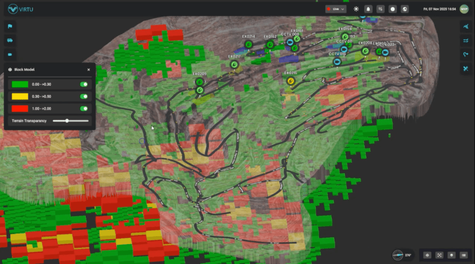
A mining digital twin is a live virtual replica of the site that is updated with operational data. Virtu describes a digital twin as a working model that shows current state, keeps history and supports monitoring, analysis and prediction.
Its focus is on what is happening now and what has happened. Typical functions include:
- 3D visualisation of current terrain
- live equipment positions and status
- real-time monitoring and alerts
- timestamped playback of past events
Virtu’s Smart Digital Twin Mining project for Petrosea combined drone LiDAR terrain data with live Fleet Management System data in a single view, delivered on web, mobile and mixed reality.
Key Differences
The three systems differ mainly in purpose:
- GIS: manages and analyses spatial data, often with a 2D map focus.
- Mine planning software: designs the mine and schedules future work.
- Digital twin: shows current and past operational conditions in a live 3D environment.
They also differ in users:
- GIS: survey, environmental and land teams.
- Mine planning: geologists and planning engineers.
- Digital twin: control rooms, supervisors, managers and planners reviewing actual performance.
And in time focus:
- GIS: mostly the present state of spatial data, updated periodically.
- Mine planning: the future.
- Digital twin: the present and recent past, updated frequently.
How They Work Together
These systems are complementary rather than competing.
A digital twin can use data produced by other systems. Survey data managed in GIS can form part of the terrain layer. Designs from mine planning software can be displayed alongside actual terrain to compare progress against plan. This comparison helps identify areas where excavation is ahead of or behind schedule.
In the other direction, information from the digital twin can support planning. Actual haul road speeds, congestion patterns and cycle times observed in the twin can inform future haulage plans.
When a Digital Twin Adds Value
A digital twin adds most value when:
- operational data exists but is spread across several systems
- users need a current 3D view rather than a 2D map
- teams need to review past events in their spatial context
- information must be shared with users who do not use specialist software
Virtu’s digital twin page notes that a 3D topographic view provides more useful context than a flat satellite map for a mining site that changes constantly.
Integration Considerations
Using these systems together requires:
- shared coordinate reference systems
- agreed data formats for exchange
- clear ownership of each data source
- defined update schedules
Summary
GIS manages spatial data, mine planning software designs future operations and a digital twin shows current and past operations in a live 3D view. Used together, they give a more complete picture of the mine. Mining companies can contact Virtu to discuss how a digital twin could work alongside their existing systems.